GIS Kit app good for
This is the most complete and best developed app about geo I have ever seen!
Makes each cent worth!
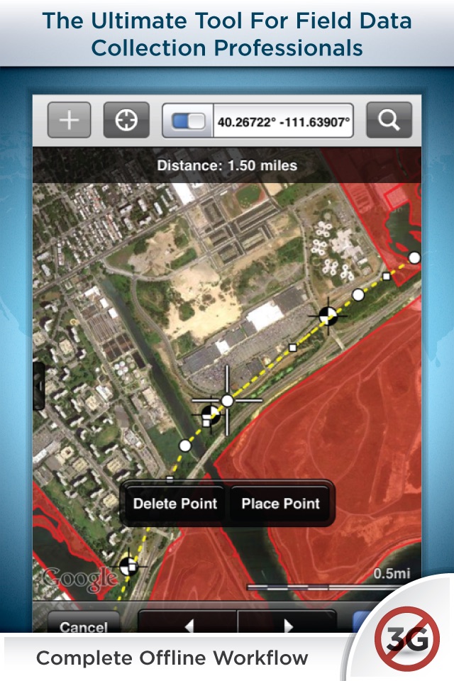
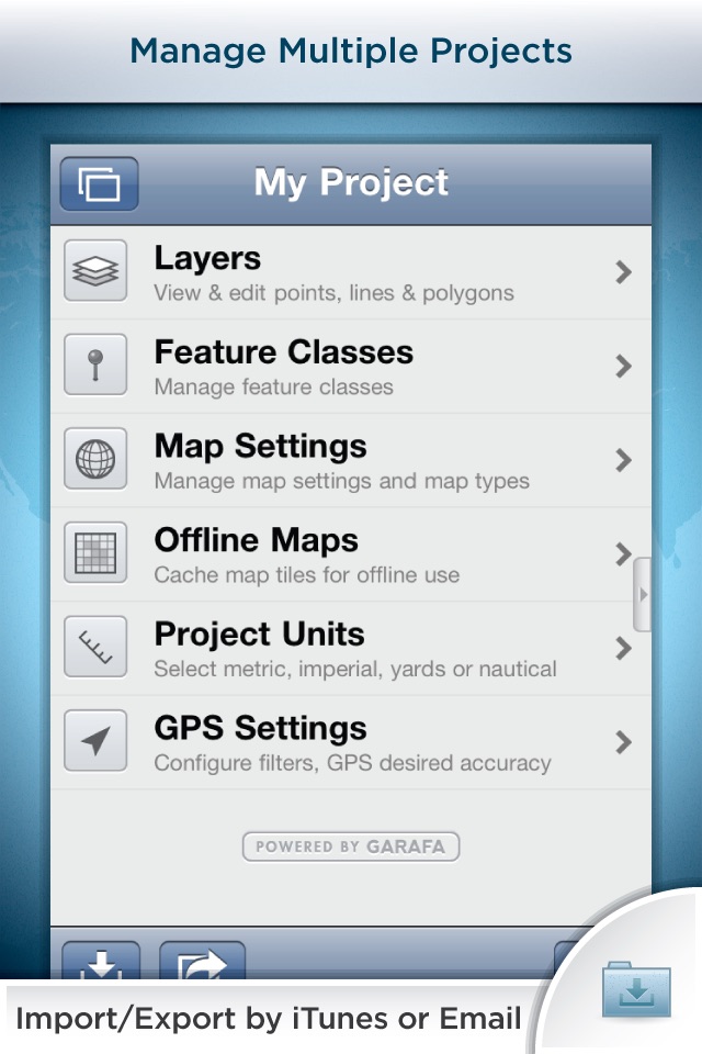
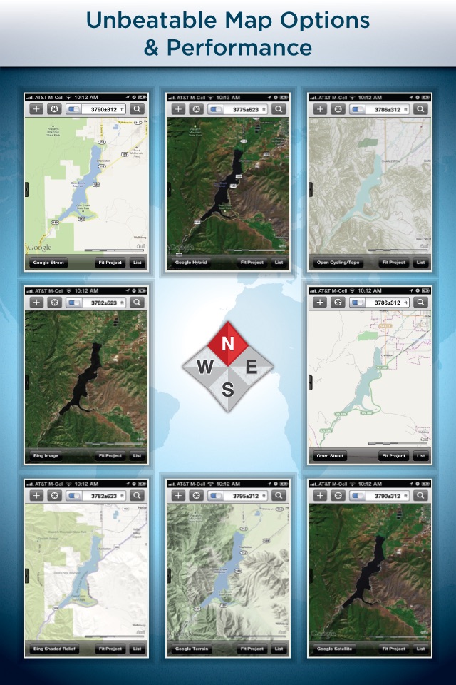
Very functional mobile GIS application. Easily collect and capture spatial and attribute data with GPS or manually. GPS navigation a breeze. Data import and export also quick and easy. Great selection of base maps which can be easily buffered for offline field data capture. Auto capture of GPS tracks while you collect your other data. Easily toggle your data layers on and off and set symbology and transparency as required.
Ive been using this app to do my forest technology & GIS labs at Vancouver Island University, so far its worked really well, very easy in the field, easy to build a new feature template on the fly when you want to capture some data you didnt expect. Earlier versions had some crashing issues, but they were addressed very quickly by the developers.
It could use a few enhancements, but it seems the app is growing, and the developers are very responsive to feedback. Being a student I use the non-pro version and am able to move shapefiles/geodatabase features in and out via KMZ files. Not ideal as the field data gets formatted very ugly on the way from the iOS device back into ESRI, but nothing too horrible. I guess the pro version saves you this step since i believe it exports shapefiles.
I looked at several other iOS GIS field data collection apps, but this ones interface is the best in my opinion.
I probably spent $100 on $2-$5 apps trying to find one that worked well with shape files and offline satellite images. All the other apps were lacking in one way or another.
This app has worked flawlessly and is very stable. If you compare the price to an ArcMap license, it is a steal of a deal.
I finally have access to offline maps in the field with all my critical shapefiles from the office..... On an iPhone 4s.
Replaces the bulk of features offered by ArcPad and other professional GIS data capturing software; only, you dont have to go to university for 5 years to know how to use it! It is as intuitive as Apple products themselves.
ArcGIS is a dinosaur; offering an alternative to their crap is Heaven sent! I love the export options too. My only complaint there is that you cant export all your shapes at once.
I dont know what the heck that winer critic is going on about; I paid $400 for the Pro version and, over the past 2 years, I have made my money back from it almost a thousand times over..., I guess this software just doesnt meet his specific needs.
Thank God, professional grade GIS products like lasers and GPS receivers are finally being made to work with iOS! I used to use sub-metre stuff all the time, but I found that most of the users I supervised, were pathetic at achieving sub-metre accuracy regardless of the equipment capabilities. So using the primary method of coordinate capture that this offers (positioning the screen as per imagery background), combined with laser trigonometry, works much better. And of course, you still have the traditional GPS capturing methods with this software too.
Good stuff Garaffa
What can I say, $100 is worth every penny. No subscription fees. Switching to this from wolfgis pro for sure
Some bad moments
First of all, the App offers good prerequisite to collect field data with offline maps and many GIS related features.
But it is extremely unstable! Im not able to work more than five minutes without a collapse of the App. It happens in any occasion, and is highly annoying because often data gets lost!
The App-Support is no help, here is a 4-week-old reaction of the Developer Team: “Unfortunately, it will take some time to correct these issues.” So there is no prospect of an end, and it sounds like a bad joke for a 100€ App! Honestly this is the most labile App ive ever loaded in the App-Store.
Keep your hands off!
I bought GIS Kit approx. 13 months ago and there hasnt been a single substantive update since. The only updates have been bug fixes and cosmetic tweaks and that is extremely disappointing given that I paid the hefty price tag more for the apps considerable potential then for its current set of features. One of the most perplexing things is that Garafka makes a product called GPS Kit, as opposed to GIS Kit, and it has better capabilities (e.g., track logs). I have GIS Kit on both my iphone and my ipad and havent used it all field season despite the fact that it burns my #$@#$ that I paid that much for an app. I contacted the developers on multiple occasions to ask about potential features and they never ever had anything intelligible to say. Finally, apple products simply cannot collect professional GPS-GIS data because Apple doesnt allow the necessary bluetooth protocols, i.e., the serial port protocol needed to permit survey grade GPS units to connect to iOS devices.
Wait for the Windows 8 devices.
Crashes, consistently in line features when using Record to GPS.
I have many small issues with this program but crashing and losing precious data on a day to day basis is costing my company money and my mapping technicians are losing faith in this program.
We upgraded to pro but I cant leave a comment there since it was an in app purchase, So I will leave this here.
We are consistently losing data and we need to redo line features often , which is quite difficult in some of the terrain I map in.
This is the most expensive app we use and it is the one with the least customer support.
There is no crash reporting , if there was I am sure this problem would be addressed.
Please fix.
contact
Geochange at gmail dot com
This App has its issues and could be much better. The best GIS App on the market is WolfGIS Apex.
Finally a GIS app that does exactly what it says. Great interface, fast, powerful and easy to use. Tons of pre loaded features and attributes, and super easy to create new ones as needed. A little pricy, but worth every bit. Cant wait for the Pro features to come out.
I own several GIS apps due to my work. We work in the field everyday collecting field data and we are trying to find the best app that will help us do our job better. I think GIS Kit has potential but its not perfect. So with that said I will re-think my 1 star rating because Ive used the app very extensively over the last few weeks. But I will not change my rating of ArcGIS because theyre over rated and too expensive. About 80% of the people that use it only use 20% of its capabilities. There are a lot of great GIS apps out their, my advice would be try as many as you can and pick the right ones that fit your needs because all are a little different in there own way.